
ISRO’s Bhuvan Centre was able to locate the proper location, drainage pattern, paleochannels and its origin through modern tools like Remote Sensing and GIS by using multi-spectral and multi-resolution satellite images of optical and microwave data. Further, they were able to delineate most of the palaeochannels of Vedic Saraswati River and its linkage with the present day Himalayan Rivers.
The Saraswati River in the Rigved, Manusmriti, Mahabharat and Puran
Rigved
In the Rigved (one of the four Veds), the Saraswati River is described as a mighty one, suggesting strong water flow that could have been only possible if it received water flows from both seasonal streams as well as glaciers.
Rigveda Mandala 10, Sukta 64, Mantra 9:
सिन्धुं सरस्वतीं सरयूं सुषोमं सदानीरम् ।
आपो देवीर्बहुलाः सन्ति विश्वेदेवा अनुसंस्तुतः ॥
“The Sindhu, Saraswati, and Sarayu, the well-juiced [rivers], continuously flowing; these divine waters are plentiful, praised by all the gods.”
Manusmriti
Manusmriti mentions Brahmavarta as the land between the Saraswati and the Drishadvati Rivers.
Mahabharat
Kurukshetra, the famed battlefield where the Kurukshetra War takes place, is said to be located between the Saraswati and the Drishadvati rivers.
Markandeya Puran
While some scholars argue that the Markandeya Puran mentions the Saraswati River, we found no such explicit mention which led us to the conclusion that since the river had already been extinct by the Puranic age, it could have been possible that some form of knowledge about the river trickled through time but wasn’t enough to make an explicit description of the river.
The Vedic Era Was Well Established Before Sindhu Saraswati’s Decline in the Sindhu-Saraswati Doab
The Vedic era possibly flourished between the Sindhu River and the Saraswati River around the present day Haryana region. This could also be the reason why Mahabharata mentions the Saraswati River and not Markandeya Puran.
The most accepted date for Mahabharata war is around the late fourth millennia to early third millennia BCE. At that time, Saraswati could have been nearing its extinction.
There is another possibility that the tectonic shift that erased the Saraswati River also erased a possible distributary of the river that confluence with Ganga and Yamuna at the Prayagraj Sangam.
Extinction of the Saraswati River
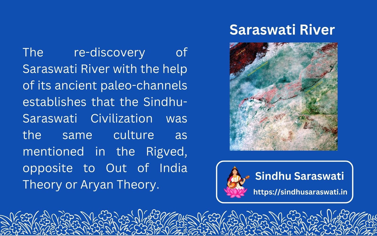
The geological evidence of the Saraswati River comes through its paleochannels (see Bhuvan Portal). The river is believed to have gone extinct somewhere around 3000 BCE.
The mention of the Saraswati River along with Sindhu clarifies that the sages who composed Rigved
Bhirdana Connection
Several dwelling pits in Bhirdana were plastered with the yellow alluvial soil of the Saraswati River. These plastered dwelling pits belonged to the Hakra Ware culture that was near the Saraswati River.
What are Paleochannels?
Paleochannels are the dried river beds where once rivers used to flow. These channels were created during the lifetime of the river due to the force of water flow. When these rivers died, the channels remained.
These channels continue to exist despite soil and dust getting filled in them. This is because all rivers erode soil in a certain pattern and even if top soil fills the river bed, the two soils below and above the river bed have different density, composition, etc. Usually there is a alluvial soil layer separating the uncut bed and the later filled top layer.
Why did Saraswati River Went Extinct?
De-Glaciation
The period of de-glaciation in the Holocene Era gave birth to glacier fed rivers like Saraswati which till then were possibly rain fed. As the glaciation levels dropped in this part of the world, many perennial snow-fed rivers slowly became dependent on monsoon waters once again.
Tectonic Shift
Tectonic shift was a very common phenomena during the period of the Saraswati River extinction. We have the following arguments that conclude high seismic activity in the region.
- Geological Layers: Disrupted sediment layers at sites like Harappa and Mohenjo-Daro indicate seismic activity.
- Structural Damage: Collapsed buildings at places like Kalibangan suggest earthquakes.
- Abandonment of Sites: Sudden abandonment of settlements, correlating with potential seismic events.
- Paleoseismological Studies: Evidence from fault lines and tectonic activity, including liquefaction features and fault scarps.
- Historical References: Ancient texts or legends might allude to catastrophic events.
- Radiocarbon Dating: Dating destruction layers to match periods of tectonic activity.
- Seismic Hazard Models: Modern models suggest the region was seismically active, matching the distribution of Sindhu Saraswati sites. For example, the Saraswati River was around the same geological parts that was affected by 2001 Charkhi Dadri earthquake. This is a highly seismic active zone.
Similar tectonic shifts also impacted the Mesopotamia and the regions of Eastern Mediterranean around the same time indicating a high level of tectonic activity in the world.